Best for
\n";
for($i=0;$i<$split;$i++){
$html.=''.$data[$i]['present'].' '.htmlspecialchars($data[$i]['name']).' ';
if(!empty($data[$i+$split])){
$html.=''.$data[$i+$split]['present'].' '.htmlspecialchars($data[$i+$split]['name'])." \n";
}
}
$html.="\n";
echo $html;
}
?>
Book and Go

Latest features


Pamporovo ski resort
Beginner runs:
9
Intermediate runs:
7
Advanced runs:
3
Total runs:
19
Chairs:
8
Drags:
6
Total lifts:
14
Parks:
1
Pipes:
1
One of Bulgaria’s leading ski areas, Pamporovo has gone from strength to strength since its privatisation in the early years of this century.
Although still offering one of the most affordable winter sports options in Europe, the resort, located in the country’s Rhodope Mountains, has shed some of its budget-only image. Now visitors can find several modern, 3- and 4-star properties gracing the base of the slopes, with similar investment being made on fast, comfortable chairlifts on the mountain.
Despite on-going expansion plans, the extent of the slopes remains very modest compared to the well-known areas in the Alps, with less than 500m (1,640ft) of lift-served vertical. Consequently more advanced skiers will likely find themselves unenthused with the offering.
Pamporovo therefore is best suited to beginners and early intermediates, and due to its location as one of the most southerly resorts in Europe, it is also one of the continent’s sunniest ski areas.
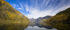
Pamporovo lies in the centre of the Rhodope mountain chain in southwestern Bulgaria, 260km (162 miles) from the capital Sofia. The range borders Greece and peaks at Mount Snezhanka, which is 1,926m high (6,319ft).
Slope Elevation
Pamporovo
Resort:
1650m
Top:
1937m
Base:
1450m
On the slopes
In spite of its low altitude, sunny weather and mild climate, Pamporovo usually enjoys a reasonable snowfall with a season lasting between late December and the middle of April. The automatic snowmaking system helps to maintain reliable cover on most of the terrain when snow is scarce, and there have also been recent improvements to the lift network with the addition of several quads and a six-seater chairlift.
Most of the main runs fan out from the peak at Mount Snezhanka, which has a viewing tower at the top. Advanced skiers and boarders have limited options, including the Snezhanka 2 black run (known as ‘The Wall’).
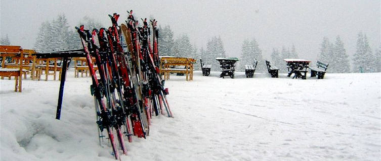
The majority of the runs are suited to beginners and intermediates, including the main beginners' ‘Tourist Track’, a 4.2km-long (2.6 miles) trail from the peak to the base. The ski schools here have a good reputation and employ over 100 qualified instructors, while ski gear can be hired at both Malina and Studenets.
In addition to over 37km (22 miles) of ski runs, there are also 38km (24 miles) of cross-country ski tracks and some off-piste opportunities for experts. The two main cross-country trails connect the villages of Studenetz and Mugla and Ardashla and Stoykite.
Snowboarders, meanwhile, can enjoy the fun park, which also includes a halfpipe – the first to be constructed in the country.
Last updated: We update the weather data for '.$title.' from the our partner every four hours. The time the last update was received is detailed here.'); ?>
Forecast Location: We have 830+ weather locations on the worldtravelguide.net site. Where no exact location is available we have used the nearest appropriate forecast point. '); ?>
Symbols indicate the predominant weather for the day in question, calculated based on a weighting of different types of weather. So if a day is forecast to be sunny with the possibility of a brief shower, then we will see a sunny or partly cloudy symbol rather than a rain cloud. For the purposes of this ski forecast, "day" is the 12 hour period 06.00 to 18.00. '); ?>
temperature is the highest temperature forecast during the indicated night or day period, and the minimum temperature is the lowest temperature expected during the indicated night or day period. The temperature is in °C, or Celsius. '); ?>
Wind speed and direction are the conditions expected on average during the indicated period. Wind direction is based on a 16 point compass: W, SW, SSW, etc. The wind direction states where the wind originates. Wind speed is listed in MPH or miles per hour.'); ?>
Pressure is measured in millibars (mb)');?>
Precipitation, or rainfall, is indicated in millimetres (mm)');?>
Last snowfall amount is measured as the last period of continuous snowfall and is displayed in centimetres (cm)');?>
Snow depths include the "Last snowfall amount"');?>
Cloud cover is measured as the percentage of clouds covering the sky at the time of forecast. So if the cloud cover shows 75% then the sky is three quarters full of clouds.');?>
Visibility based on whether the human eye can see the following distances:');?>
Average snow depth in Pamporovo
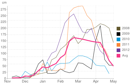
Historical snow depth in Pamporovo
language == 'en'): ?>
Do you have any Feedback about this page?
© Columbus Travel Media Ltd. All rights reserved. No part of this site may be reproduced without our written permission, click here for information on Columbus Content Solutions.
¿Tiene comentarios sobre esta página?
© Columbus Travel Media Ltd. All rights reserved. Ninguno de los contenidos de esta Web debe ser reproducido sin nuestra autorización expresa y escrita. Para más información sobre como obtener permiso para la utilización del contenido clica aquí. No part of this site may be reproduced without our written permission, click here for information on Columbus Content Solutions .
Avez-vous des commentairessur cette page?
© Columbus Travel Media Ltd. All rights reserved. Le contenu de ce site ne peut être reproduit sans autorisation écrite. Cliquez ici pour plus d'information sur notre 'des solutions de contenu’. No part of this site may be reproduced without our written permission, click here for information on Columbus Content Solutions.
Haben Sie Feedback zu dieser Seite?
© Columbus Travel Media Ltd. All rights reserved. Alle Inhalte dieser Seite sind urheberrechtlich geschützt und dürfen nur mit schriftlicher Genehmigung des Verlags genutzt werden. Weitere Informationen finden Sie in unseren Lizenzbestimmungen. No part of this site may be reproduced without our written permission, click here for information on Columbus Content Solutions .


 You know where